Through the Ad Astra Academy 2015 program in Rio de Janeiro, Brazil, 12 new images of the martian surface were acquired in partnership with the HiRISE camera team, revealing several never-before-seen features. Students worked with Ad Astra Chief Scientist Dr. Paul Hayne to interpret the images and place their findings within the broader context of Mars exploration.
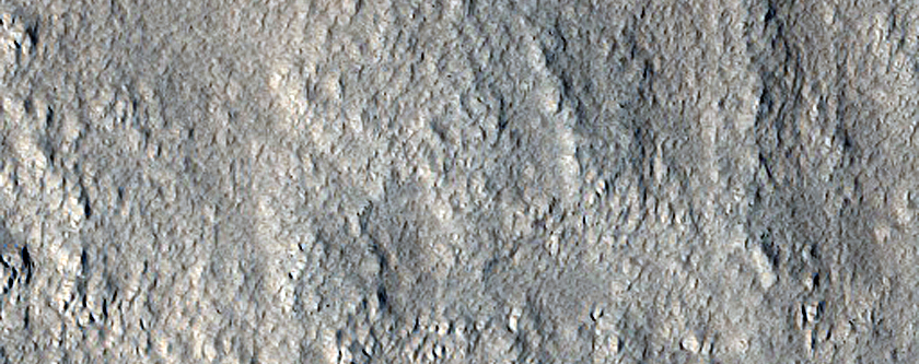
Image 1: Kasei Valles - channels and canyons
HiRISE ID: ESP_043797_2070
Science theme: Fluvial Processes
Kasei Valles comprises a system of canyons and meandering channels recording ancient outflow to Chryse Planitia to the northeast. Erosion of the flat-lying topography was most likely caused by flowing liquid water (“fluvial erosion”), originating either as rainfall or meltwater when heat produced by the nearby Tharsis volcanoes reached buried ice.
We targeted a particular branch of the Kasei Valles channel network, where two elevated older channels appear to converge on the downstream side of an island. Many fractures crisscross this area, apparently causing subsequent drainage. Our goal was to see whether the high-resolution imagery could help identify younger flow features, indicating multiple episodes of fluvial activity. Indeed, the HiRISE image (ESP_043797_2070) indicates several different ages of channels, based on their degradation and cross-cutting relationships. We also note a few dark, fan-shaped “slope streaks”, which must have occurred in the modern climate regime. These slope streaks may be due to either dry or wet processes, and further work is needed to distinguish between the two possibilities.
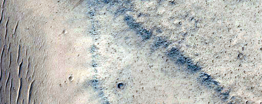
Image 2: North Polar Layered Deposits - exposure of layers
HiRISE ID: ESP_042748_2650
Science theme: Polar Geology
The North Polar Layered Deposits (NPLD) record climate variations on Mars over the last few millions of years. Spiral-shaped troughs expose layers, whose thickness and dust content may reveal past climate regimes. Some of these exposures show layers only a meter thick, or even thinner, so high resolution images are necessary to see them.
We targeted an exposure within a well-developed spiral trough in a part of the NPLD that had not been observed at high-resolution before. Our objective was to identify a stratigraphic sequence where a rover could traverse and collect samples. The HiRISE image (ESP_042748_2650) indicates layering on the meter- to decameter scale, with the primary exposure about 2 km wide -- a distance easily traversable by our simulated rover mission. On either side of the exposure, the terrain is relatively flat, so the main challenge for the rover will be ascending or descending the steep scarp. We therefore recommend ascending at an oblique angle, so the rover wheels do not slip.
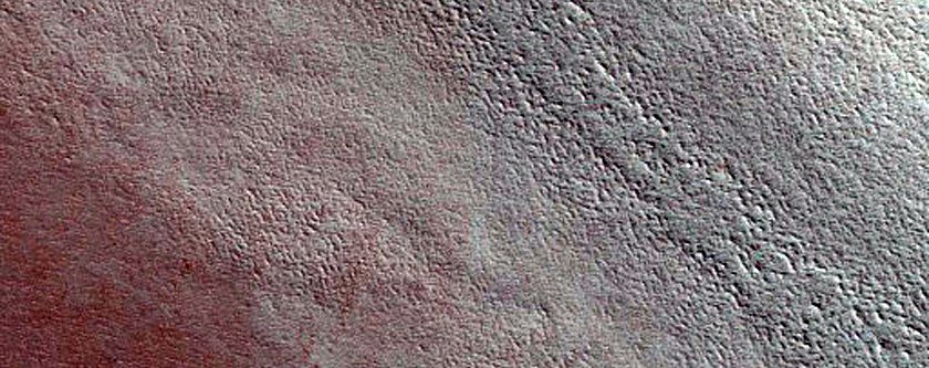
Image 3: Possible Mid-latitude Rampart Crater
HiRISE ID: ESP_042536_2170
Science theme: Impact Processes
Rampart craters are thought to be produced when the target material contains significant quantities of water. Impact ejecta are then “fluidized”, producing lobate (rounded) and overlapping sheets that are clearly visible in images or elevation data. High-resolution images are valuable in studying rampart craters, because they allow us to look for small-scale features such as blocks entrained in the flow.
We imaged a possible rampart crater in the Elysium region. Our HiRISE image (ESP_042536_2170) contains the crater floor, rim, and ejecta. These data clearly show pronounced striations in the ejecta, as well as lobate morphologies at the terminal ends of the ejecta blanket. These features are consistent with fluidization of the ejecta, possible because of the presence of ground ice. Further work is needed to explain the channel-like features surrounding some of the ejecta deposits.